

From the seafloor to today's landscape
Belgian Blue Stone was formed more than 340 million years ago at the bottom of a tropical sea. But that was by no means the end of its geological history. Burial, tectonics, uplift, and erosion determined where we find the stone today and are able to quarry it.
A journey spanning hundreds of millions of years
In the previous chapters, we saw how Belgian Blue bluestone was formed during the Viséen period, how the stone banks are structured, and what natural features they contain.
But the layers that once lay nearly horizontal on a tropical seabed are now part of a hilly landscape and emerge at the surface only in certain places.
To understand why the grooves are located exactly where they are today, we need to follow the geological story further: from being covered by younger rocks, through tectonic deformation, to millions of years of erosion.
- What happened after the Viséen?
- Overlying younger rocks
- Pressure, Folding, and Tectonics
- The Formation of the Current Landscape
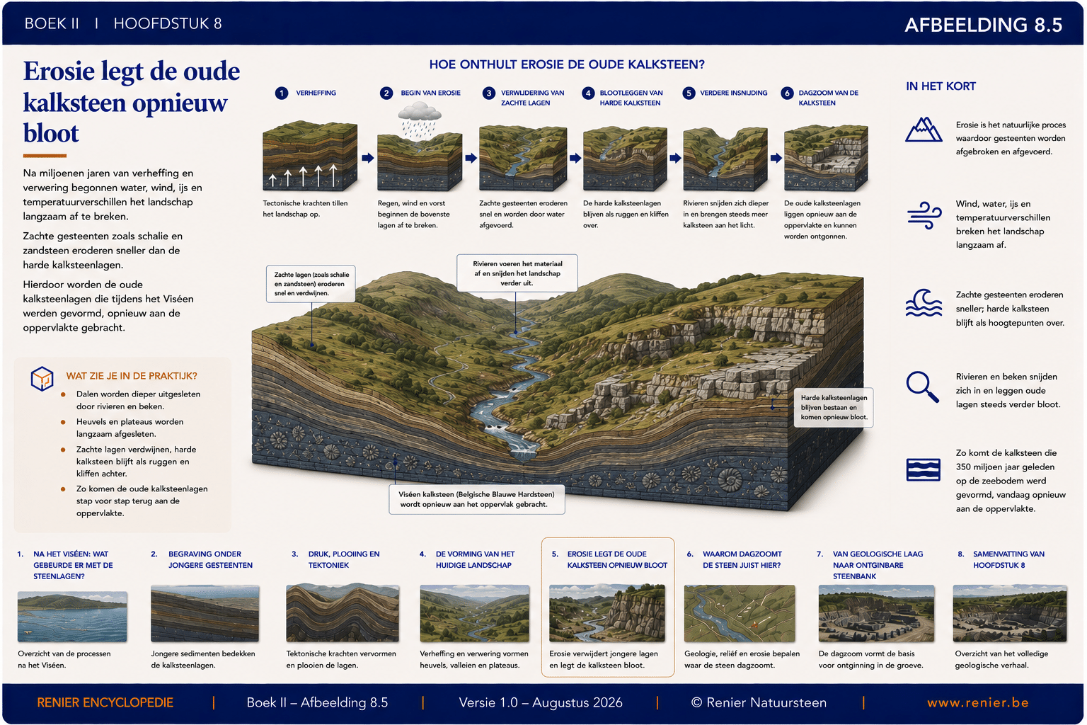
- Erosion is exposing the limestone once again
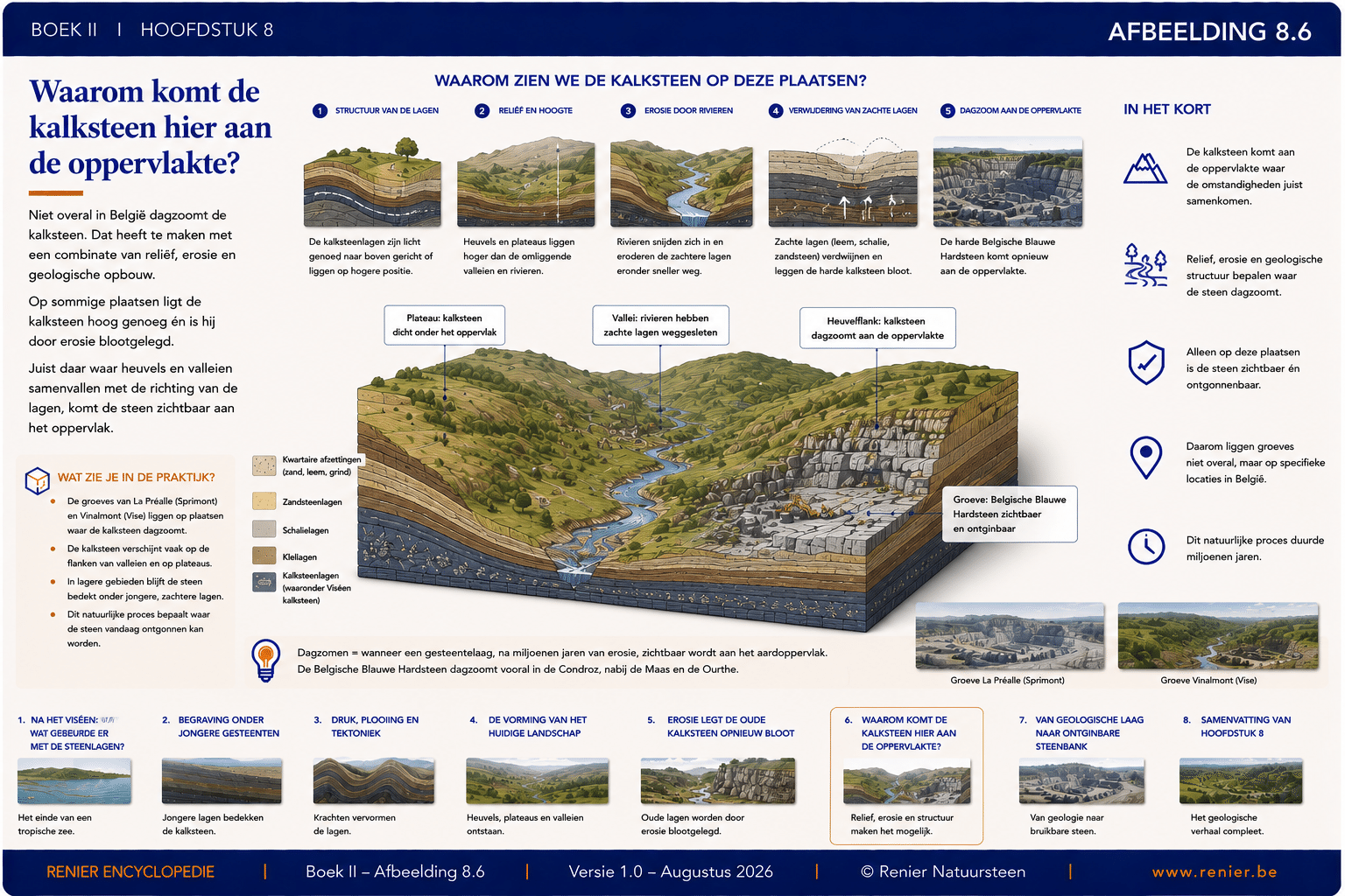
- Why does limestone come to the surface here?
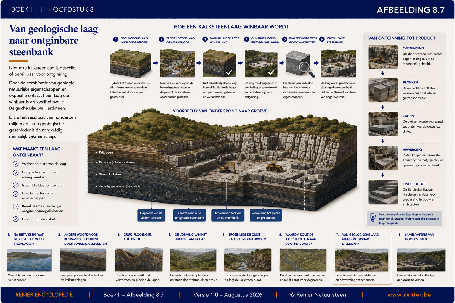
- From a geological layer to a mineable stone deposit
After the Viséen: What happened to the stone layers?
The geological history of the limestone did not end at the end of the Viséan. Conditions in the region changed, and new sediments were deposited on top of the existing limestone layers.
What was originally a relatively shallow tropical seafloor was gradually covered by younger sediments and rocks.
At the same time, the tectonic plates continued to move. Continents drew closer to one another, and enormous forces began to compress, fold, and, in some places, fracture the rock layers that had already formed.
This was followed by uplift, weathering, and erosion. As a result, the landscape in which the ancient Viséan limestone can once again emerge at the surface today was ultimately formed.
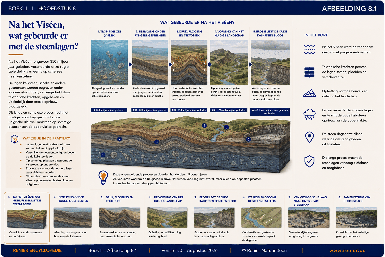
Overlying younger rocks
After the Viséen, new sediments were deposited on top of the existing limestone. Layer by layer, new layers of sand, clay, silt, and other sediments formed.
Due to ongoing sedimentation, the ancient Viséen limestone became buried deeper and deeper. In some places, the total thickness of the overlying deposits could reach hundreds of meters or even more.
That covering had significant consequences. The increasing pressure helped to further compact the rock and, at the same time, protected the limestone from immediate weathering and erosion.
As a result, Belgian Blue Hardstone remained deeply buried beneath younger rock layers for very long periods.
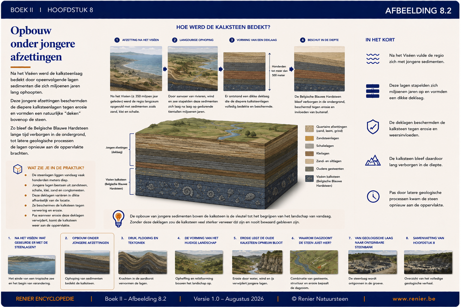
Pressure, Folding, and Tectonics
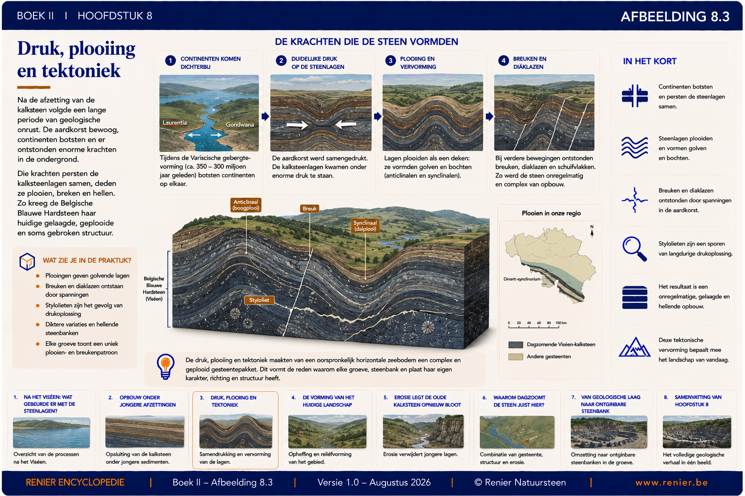
The rock layers did not remain still and horizontal. Due to the movement of the tectonic plates, large sections of the Earth's crust came under enormous pressure.
Especially during the Variscan orogeny, the rocks in our region were strongly compressed. The layers were folded, tilted, and in some places fractured or displaced along fault planes.
This is how anticlines and synclines were formed: large upward and downward folds in the successive layers of rock.
That same prolonged pressure also contributed to the formation of smaller structures in the rock, including natural fractures, diaclases, and stylolites.
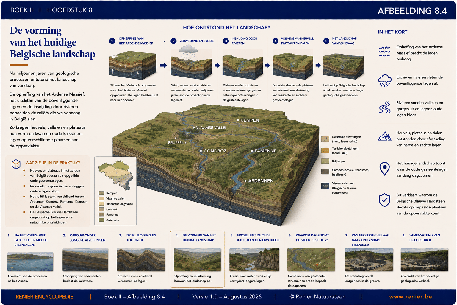
The Formation of the Current Belgian Landscape
After the major tectonic deformations, the next long phase in the geological history began: the formation of the landscape that we recognize today.
Parts of the area were gradually uplifted. At the same time, wind, rain, frost, and flowing water began to erode the rock at the surface.
Rivers cut deeper and deeper into the landscape. Softer rock layers disappeared more quickly, while harder and more resistant layers lasted longer.
This is how hills, plateaus, valleys, and steep slopes gradually formed. The current landscape is therefore directly linked to the geological structure of the subsurface.
Erosion is exposing the ancient limestone once again
The rock layers that covered the Viséen limestone did not remain intact forever. As soon as the rocks came closer to the Earth's surface, weathering and erosion began to take their toll.
Rain, running water, frost, temperature fluctuations, and rivers gradually eroded the rock and carried away loose material.
Softer rocks usually eroded more quickly than compact, resistant limestone. As a result, limestone layers were able to gradually rise closer to the surface.
Rivers played a special role in this process. By cutting into the landscape, they were able to remove younger layers and expose older rocks once again.
Why does limestone come to the surface here?
Belgian Blue Stone does not occur everywhere in Belgium on the surface. For it to occur there, various geological conditions must align precisely.
First, the appropriate Viséen limestone must be present in the subsurface. Next, tectonic movements must have raised the layers high enough or folded them into a favorable position.
After that, erosion must have removed a sufficient amount of younger rock. Especially along valleys, slopes, and river gorges, older layers can thus come close to or reach the surface.
When a rock layer becomes visible at the Earth's surface, geologists refer to it as daytime. We call the visible zone the "day zoom.".
From a geological layer to a mineable stone deposit
The fact that a layer of limestone is found at or just below the surface does not automatically mean that it is suitable for natural stone quarrying.
A quarryable stone bed must be sufficiently thick and continuous and have a suitable natural structure. Fractures, jews, and other discontinuities must not unduly restrict the extraction of usable blocks.
In addition, color, texture, fossil content, and technical properties are evaluated. The accessibility and safe extraction of the deposit also play an important role.
Only when all these conditions are met can a portion of the geological layer be selected as a high-quality and economically viable quarry.
From the tropical seafloor to the quarry
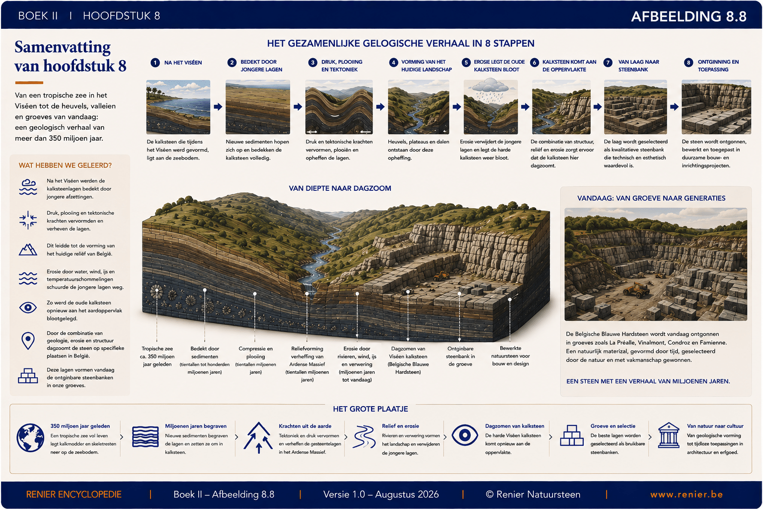
The landscape and the quarries where we find Belgian Blue Bluestone today are the end result of a geological process that lasted hundreds of millions of years.
Geology determines where the quarry can be located
When a block of Belgian Blue Stone is quarried today, it marks the end of an exceptionally long natural history.
Organisms in a tropical sea provided the calcium carbonate. Sedimentation formed the layers. Burial and diagenesis turned them into rock. Tectonic forces folded and deformed the rock, while erosion, hundreds of millions of years later, exposed it once again.
The location of a quarry is therefore not solely a human decision. It is determined primarily by geology. Belgian Blue Stone can only be quarried where the right stone deposit is present, accessible, and of suitable quality.